fbpx

26 Days Luxury Arctic & Greenland Cruise – Nuuk to Nome

26 Days Luxury Arctic & Greenland Cruise – Nuuk to Nome

From AUD $83,600

Description

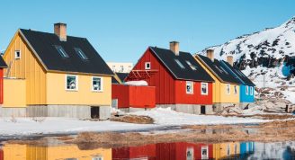
An expedition for the ages: venture from the dramatic fjords of Greenland to Alaska’s immense panoramas. Traverse the fabled Northwest Passage, which has captivated courageous explorers for centuries, navigating drifting icebergs and thick icy floes. A reward of aqua-blue glaciers, hazy mountains, and remote Inuit encounters await. Hardy whales, polar bears and arctic foxes are potential companions throughout this adventure of the remote north.

Trip Name
26 Days Luxury Arctic & Greenland Cruise - Nuuk to Nome
Days
26
Overview
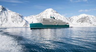
Vessel Type: Luxury Expedition Length: 164.40 metres Passenger Capacity: 200 Built: 2021 Designed for polar exploration, Silver Endeavour breaks the ice of luxury expedition travel. We’re proud to announce that our newest addition has joined the fleet. Built to PC6 Polar Class specifications – one of the highest Polar Class classifications there is – Silver Endeavour revolutionises our expedition voyages, and allows us to travel deeper to some of the planet’s farthest flung coasts. Her statistics speak for themselves: from unrivalled, industry-leading crew-to-guest, zodiac-to-guest and expert-to-guest ratios, to cutting-edge navigation and exploration technology and hallmark Silversea comfort make her the most luxurious expedition ship ever built. Spread over eight public decks, not only does she feature ample onboard space, multiple restaurants, plus a huge choice of bars and lounges, but her large and luxurious suites are some of the best in expedition cruising. Superbly designed, all her suites feature a balcony and our highest standards of service thanks to an impressive crew-to-guest ratio of 1:1. Mud Room Silver Endeavour’s Mud Room is the perfect place to prepare for all your expedition activities. Spaciously designed, the two mud rooms are superbly modern, and equipped with state-of-the-art equipment. Explorer Lounge Strategically located mid-ship on deck 4, the Explorer Lounge is the operational heart of shore excursions while onboard. This is where you’ll attend your daily recap and briefing sessions or attend lectures. Connoisseur’s Corner The Connoisseur’s Corner is an indulgent and sophisticated cigar lounge, where you can enjoy an after dinner drink in a cosy private club atmosphere. Otium Spa Otium is where you can relax and unwind, but also where you can enjoy world class treatments that make sure you look as good as you feel and that even Venus herself would envy. Observation Lounge The Observation Lounge offers one of our favourite vantage points of Silver Endeavour. Plus 270-degree surrounding glass windows make this immersive venue ideal whatever time of the day. Beauty Salon Our committed and competent team of beauty therapists is here to help keep your hair, nails, skin, and body healthy and happy. Fitness Centre Whether you are a serious keep fit fanatic or casual athlete, you’ll find what you’re looking for in Silver Endeavour’s Fitness Centre. Expertly designed classes and personal training sessions make sure that you keep in shape. Boutique Located mid-ship on Deck 5, the Boutique aboard Silver Endeavour means luxury shopping experiences do not end just because you’re at sea! Carefully selected partners offer a wide selection of the latest fashions. Pool Deck Surrounded by glazing extended all the way to the top of the venue, the Pool Deck gives you the feeling of always being connected to the sea. The glass-enclosed pool deck is the ideal place to enjoy breathtaking views. Library Whether you’re an avid bibliophile or simply prefer a quiet place while at sea, it’s hard not to fall in love with Silver Endeavour’s onboard library, with its beautiful reference books, comfortable chairs and stunning scenery.

Itinerary


Day 1 - Days 0 - 1 - Pre Cruise & Nuuk (Godthab)
Pre Cruise BenefitsPrivate Executive TransfersInternational flights - Economy classor Business Class upgradeAirport transfersHotelCharter/Group flightsIn the bustling capital city of Greenland, you could be forgiven for forgetting you are in such a vast and isolated country. Nuuk is Greenland's economic and social hub, home to more than a third of Greenland's population, and although it feels like a world capital, scratch the surface, and a uniquely Greenlandic character can be found underneath. Nuuk Cathedral overlooks the gorgeous old Colonial Harbour district and the Greenland National Museum, resting place of the legendary Qilakitsoq mummies, the true highlight of the museum's archaeological collection. Above the Colonial Harbour sits downtown Nuuk, with lines of Scandistyle apartments, a bustling shopping district, the Greenlandic Parliament, Nuuk City Hall (which welcomes visitors to see its artwork) and even outdoor cafes selling locally produced food and beer. These nods to modernity compete for space with local artisan boutiques, the meat market selling the catch from Nuuk's vast fjord-lands, and the stunning Katuaq Cultural Centre, where blockbuster movies, as well as local and foreign performers entertain the people of Nuuk. Although Nuuk has long been a melting pot of Danish and Greenlandic ideas, this is a city where Greenland displays its sophistication, with the Country's only traffic lights, roundabouts and University. Most of all, expect to find a multitude of friendly people who are proud of who they are, and equally proud of the city they call home.
Day 2 - Day 2 - Sermilinnguaq
Some 60 kilometers southeast of the entrance to Kangerlussuaq Fjord and halfway between Maniitsoq and Kangaamiut is Sermilinnguaq, one of the smaller fjords leading to the Greenland Icecap’s westernmost valley glaciers in South Greenland. Northeast of Maniitsoq’s rugged scenery with peaks rising hundreds of meters into the sky, the narrow fjord with its steep mountainsides is one of the preferred halibut fishing areas for the local fishermen from Maniitsoq and Kangaamiut. In 2019, the Greenland Environment Fund granted resources to clean up and remove derelict fishing gear which had washed up along the Sermilinnguaq Fjord based on the fishermen’s request. Razorbills, Brünnich’s Guillemots (Thick-billed Murres), Common Guillemots, and Black Guillemots, Glaucous Gulls, and Black-legged Kittiwakes –all attracted by the rich fishing grounds- have formed eight bird colonies in Sermilinnguaq. As a result, 3,000 hectares of the fjord are considered an Important Bird Area.
Day 3 - Day 2 - Maniitsoq
Located in the central part of Greenland’s western coast, Maniitsoq is Greenland’s sixth-largest town, and home to less than 2700 inhabitants. The main attractions are the small museum and old cemetery at the northern end of town. At the community hall local artist and artisans usually exhibit some of their carvings and beadwork. The beadwork pieces are not created just as souvenirs for visitors — the national dress of the West-Greenlandic women uses an elaborately beaded collar. Fishing trips and even heli-skiing on nearby mountains are considered Maniitsoq’s other assets. Its local name (meaning ‘place of rugged terrain’) contrasts somewhat with the name given by the Danish in 1782 (‘New Sugarloaf’).
Day 4 - Day 3 - Evighedsfjord
Evighedsfjord (Eternity Fjord) is a large fjord northeast of Kangaamiut in southwest Greenland. The fjord has a length of 75 kilometers and several branches with numerous glaciers coming down from the Maniitsoq Ice Cap to the north can be seen. The Evighedsfjord has several bends and whenever the ship reaches the supposed end the fjord continues in another direction and seems to go on forever. Qingua Kujatdleq Glacier is at its southeastern end. At the northwestern end a U-shaped valley has seven glaciers coming down from the mountains but not reaching the water. The glaciers had their maximum extent around the year 1870 and have gone through several cycles of advance and retreat. The mountains on either side of the fjord can reach in excess of 2,000 meters and the fjord has a depth of up to 700 meters. Evighedsfjord’s snowline is at 1,100 meters and the Evighedsfjord region is famous as one of Greenland’s best heli-skiing areas.
Day 5 - Day 3 - Evigheds Glacier
The Evigheds Glacier flows from the Greenland Ice Sheet, the second largest ice body in the world after the Antarctic ice sheet, to the west. It is a slow-moving tidewater glacier, meaning this valley glacier winds down through the coastal mountains to the ocean at a snail’s pace. As the glacial ice enters the water it begins to float and the eventually breaks apart into icebergs that float away down the fjord. The shades of blue and carved shapes of these ice floes are infinite.
Day 6 - Day 4 - Sisimiut
Sisimiut ('The People of the Fox Holes') is Greenland's second city, the largest Arctic City in North America, and a hub between the warmer South and the frozen North of the country. With a young, dynamic population, including students from all over the country, Sisimiut is one of the fastest growing cities in Greenland. Inhabited for more than four and a half thousand years, the Danish Colonial Era saw the rapid development of the city into a trade centre, and the old buildings and artefacts can be seen at Sisimiut Museum, a collection of beautifully restored buildings displaying everything from ancient turf houses to modern Inuit art. The local artisans are considered some of the best in Greenland, and often sell their wares direct from their communal workshop in the harbour, where they barter with hunters for raw materials. Today, modern industry focussed on processing sea food and shipping; KNI, the state-run chain of general stores operating in even the most remote settlements is based in Sisimiut. Most residents still live in the colourful wooden houses Greenland is so well known for. Sisimiut's vast back country offers excellent opportunities for hiking and fishing, and the locals often use sled dogs or snowmobiles to get around their vast mountainous playground during the long winters. In the summer, one can walk as far as Kangerlussuaq International Airport, a trail also used for the gruelling Polar Circle Marathon, one of the toughest endurance events in the world.
Day 7 - Day 5 - Ilulissat
Known as the birthplace of icebergs, the Ilulissat Icefjord produces nearly 20 million tons of ice each day. In fact, the word Ilulissat means “icebergs” in the Kalaallisut language. The town of Ilulissat is known for its long periods of calm and settled weather, but the climate tends to be cold due to its proximity to the fjord. Approximately 4,500 people live in Ilulissat, the third-largest town in Greenland after Nuuk and Sisimiut. Some people here estimate that there are nearly as many sled dogs as human beings living in the town that also boasts a local history museum located in the former home of Greenlandic folk hero and famed polar explorer Knud Rasmussen.
Day 8 - Day 6 - Uummannaq Fjord
Fjords were carved by glaciers and Uummannaq Fjord must have been carved by an enormous one in the past. This fjord is about 160 km (100 miles) long and 24–48 km (15–30 miles) wide as it extends eastward to the Greenland ice cap. The main fjord divides into several smaller fjords also fed by glaciers. Store Glacier, or Great Qarajaq, is one of the world’s fastest moving at 5.7 km (3.5 miles) a year. It sheds icebergs that float, melt, develop strange shapes and pose for photographers. Sheltered conditions at Uummannaq Fjord suited people. First the Saqqaq culture inhabited the area between 2500 BCE and 800 BCE and then the Inuit. A famous mummy of a 6-month-old boy is now displayed at Nuuk museum. Found at Qilakitsoq within the fjord, the boy has been preserved in remarkable condition by cold dry air for 500 years. Today Inuit live in eight colourful settlements in the fjord, with Ummannanaq having the most people and facilities. Hunting, fishing and many other cultural traditions continue to be important for the communities. Wildlife in the fjord thrives during the long summer days. You will probably see whales at some stage with Fin, Humpback and Minke Whales the most common. Ashore, Arctic Foxes lose their white winter fur and grow a brown coat for summer. Arctic Hares however keep their white coats all year round in this area. Remote parts of the fjord have Musk Oxen. Northern Fulmars are common seabirds and Black Guillemots, Iceland Gulls and Glaucous Gulls often fill the binocular views.
Day 9 - Day 7 - Day at sea
Days at sea are the perfect opportunity to relax, unwind and catch up with what you’ve been meaning to do. So whether that is going to the gym, visiting the spa, whale watching, catching up on your reading or simply topping up your tan, these blue sea days are the perfect balance to busy days spent exploring shore side.
Day 10 - Day 8 - Pond Inlet, Nunavut
Located in northern Baffin Island Pond Inlet is a small predo¬minantly Inuit community with a population of roughly 1 ,500 inhabitants. In 1818 the British explorer John Ross named a bay in the vicinity after the English astronomer John Pond. Today Pond Inlet is considered one of Canada's "jewels of the North" thanks to several picturesque glaciers and mountain ranges nearby. Many archaeological sites of ancient Dorset and Thule peoples can be found near Pond Inlet. The Inuit hunted caribou, ringed and harp seals, fish, polar bears, and walrus, as well as narwhals, geese, ptarmigans and Arctic hares long before European and American whalers came here to harvest bowhead whales. Pond Inlet is also known as a major center of Inuit art especially the printmaking and stone carving.
Day 11 - Day 9 - Dundas Harbour, Devon Island
Austere, remote and a rather severe, Devon Island is as close the closest thing to Mars on planet Earth. The rocky terrain, dry, cold climate and 14-mile wide crater on the north of the island have made it home for a team of research scientists from NASA, who live in the small research station during the Arctic summer. Other than these few men and women, Devon Island is completely unpeopled, and the largest uninhabited island in the world. There was human habitation as recently as 1951, when a Canadian Mounted Police post that had been on the island since 1924 to monitor illegal activities such as whaling closed. At 320 miles long and 80–100 miles wide, it is the largest of the Parry Islands. Dundas Harbour is found in the south of the island. Then island is set in the icy Arctic Ocean, south of Ellesmere Island and west of Baffin Bay. This make it Canada’s sixth largest island. Discovered by English explorer William Baffin in 1616, the island did not make it on to any maps until William Edward Parry’s exploration of the Arctic in 1820. Despite the desolate conditions, the island does show signs of having sustained human life as many as 3,000 years ago, with the remains of a Thule settlement dating back to 1000 A.D., including tent rings, middens and a gravesite providing testament to the fact. The island is named Talluruti in local Inuktitut language, literally translating as “a woman’s chin with tattoos on it”, as from a distance the deep crevasses resemble traditional facial tattoos.
Day 12 - Day 10 - Devon Island (Radstock Bay)
Devon Island is Canada’s sixth largest island and was first seen by Europeans in the early 17th century. The Thule culture had already settled there many centuries before, and left behind qarmat homes, made of rocks, whale bones, rock and sod walls, and skins for roofs that tell a story of over 800 years of human habitation. Other striking finds in this area are the many fossils of corals, crinoids and nautiloids that can be seen. Just across Lancaster Sound is Prince Leopold Island, a Canadian Important Bird Area, a federally listed migratory bird sanctuary, and a Key Migratory Bird Terrestrial Habitat site with large numbers of Thick-billed Murres, Northern Fulmars and Black-legged Kittiwakes that breed there.
Day 13 - Day 10 - Beechey Island
Beechey Island is a small island off the southwest coast of Devon Island, separated by a narrow waterway called the Barrow Strait. Captain William Edward Parry was the first European to visit the island in 1819. His lieutenant, Frederick William Beechey, named the island after his father, the artist William Beechey (1753–1839). Beechey Island played a significant role in the history of Arctic Exploration. During the winter of 1845-46, Sir John Franklin and his men camped on the island as part of their ill-fated quest to find the Northwest Passage. Mummified remains of three of Franklin’s crew were discovered, giving a better understanding of what happened before the disappearance of the expedition. In 1850 Edward Belcher used the island as a base while surveying the area. Later, in 1903, Norwegian explorer Roald Amundsen stopped at the island at the beginning of his successful voyage in search for the Northwest Passage. Subsequently, Beechey Island has been declared a "Territorial Historic Site" by the Northwest Territories government in 1975 and a National Historic Site of Canada in 1993. It now is part of Nunavut.
Day 14 - Day 11 - Cruise Bellot Strait
Carefully navigating the narrow and fabled Bellot Strait is an exhilarating experience, which encapsulates all of the thrills of Arctic exploration. The slender channel between Prince Regent Inlet and Peel Sound is approximately a mile wide and 16 miles long, and the deep, cold and arctic-blue waters are dotted with ice floes. The Bellot Strait separates Somerset Island to the north and the Boothia Peninsula to the south and is a true adventurer's bucket list item. Renowned for its challenging navigation, the swirling currents mean it is best negotiated at high tide. As you sail, keep an eye out for the northerly landmark that emerges halfway along the passage - the Murchison Promontory is the northernmost point of mainland North America. Marine life also makes good use of this navigational cut-through, with beluga whales and long-tusked narwhals - the unicorns of the sea - transiting through the nutrient-rich waters. The team will also be close by with binoculars because it's frequently possible to spot polar bears traversing the untouched landscapes. The strait takes its name from Joseph René Bellot, the French navy officer who - along with William Kennedy - was the first European to encounter it in 1852. They arrived by dogsled and proved that Somerset Island was, in fact, separate from the mainland.
Day 15 - Day 12 - Coningham Bay
a:0:{}
Day 16 - Day 13 - Gjoa Haven, Nunavut
King William Island’s flat coastal terrain holds only one settlement. Although the area around Gjoa Haven had already been used by the Netsilik Inuit, the Scandinavian name was given to it by Amundsen during his crossing of the Northwest Passage when he overwintered for two years with his ship Gjøa in the natural harbor on King William Island’s southeastern side. 250 kilometers above the Arctic Circle the average temperature hovers around 0 degrees Celsius in September. Amundsen’s presence (with a ship full of interesting supplies specifically brought for trade) attracted Netsilik from camps in the vicinity. The Netsilik had been here at Usqsuqtuuq -meaning “place of plenty blubber”- because of the fat fish and sea mammals in nearby waters. In 1927 the Hudson’s Bay Company set up a trading post and the community has grown from then on. Today some 1,500 predominantly Inuit inhabitants live in Gjoa Haven. There is a path connecting several sites forming the Northwest Passage Territorial Trail, including the Heritage Centre, the Hamlet Centre where one can learn about the early European explorers and their fate, and places used by Amundsen. Artifacts relating to Franklin’s expedition were found near Gjoa Haven and the wrecks of his two ships Erebus and Terror have recently been located not too far away. Although there are some muskoxen and caribou on the island, a different attraction for some is a nine-hole golf course, known to be Nunavut’s most northerly.
Day 17 - Day 14 - Cambridge Bay, Nunavut
The area around Cambridge Bay was seasonally used by Pre-Dorset, Dorset, Thule, and Copper Inuit to hunt and fish. It was only after the Royal Canadian Mounted Police and the Hudson’s Bay Company decided to set up posts on Victoria Island in the 1920s that outsiders settled, while the Inuit community only came to live at Cambridge Bay in a more permanent way after World War II when a LORAN tower was built. Today Cambridge Bay is one of Canada’s northernmost villages with close to 1,800 residents. It is the administrative center for the Kitikmeot region and an important transportation hub for cargo by sea and air. Arctic char, which is caught in rivers nearby, is Cambridge Bay’s major export article. For many years Cambridge Bay was the home to Roald Amundsen’s ship Maud. Having served in the Arctic for several years, the ship was brought to Cambridge Bay by the Hudson’s Bay Company where she was beset by ice in 1926 and sank in 1930. The Maud was eventually raised and transported to Norway where she is to be exhibited in a museum.
Day 18 - Day 15 - Edinburgh Island, Nunavut
a:0:{}
Day 19 - Day 16 - Ulukhaktok, Northern Territories
a:0:{}
Day 20 - Day 17 - Smoking Hills (Northwest Territories)
The Northwest Territories’ Smoking Hills show a natural phenomenon which has probably been active for thousands of years. The hills close to the Beaufort Sea were seen by John Franklin in 1826 during his second Canadian expedition looking for indications of a Northwest Passage. Franklin observed that the rocks and soil around Cape Bathurst seemed to be on fire and produced acrid white smoke. They were therefor named “Smoking Hills”. The reason behind this phenomenon is neither human-induced burning nor volcanic activity, but the subsurface exothermic reaction between the bituminous shale, the sulfur and the iron pyrite of the area. The heat being released through the oxidation of pyrites in the Cretaceous mudstones along the sea cliffs leads not only to high ground temperatures, but also to hot sulfurous gas being driven off and the possibility of spontaneous combustion. The fumes that are seen contain sulfur dioxide and sulfuric acid and are noxious.
Day 21 - Day 18 - Ice Edge Cruising
From the edge of the mosaic of ice stretching to the North Pole, it really can seem like the edge of the world. Wrap up warm, bring your binoculars, and join your Expedition Team outside to experience the raw majesty of the Arctic Ocean.  The bewilderingly complex maze of ice seems barren, but hides a wealth of life. Perhaps a smear of colour is spotted on the horizon. Perhaps it turns out to be the dark fur of a snoozing seal, or a plump pink mother walrus nursing her calf, standing out against the bright white ice. Or maybe luck will favour us, as the ice is stained red by a polar bear, king of the Arctic, feasting on prey hauled from the frigid ocean. These magnificent animals are perfectly adapted to hunt seals or even animals as large as beluga whales in this harsh oceanscape, roaming thousands of miles across the ice in their never ending hunt for food. As the ship draws closer, we could be lucky enough to watch Earth's largest carnivore going about his business in his frozen kingdom, plodding across the ice, or paddling through the frigid water, constantly alert for prey. At the top of the food chain, these beautiful carnivores crown the Arctic ecosystem, but their kills often provide for many more animals, such as Arctic Skuas and elegant Ivory Gulls.
Day 22 - Day 19 - Herschel Island (Yukon Territory)
Three kilometers off Yukon’s north coast, only Workboat Passage separates Herschel Island-Qikiqtaruk from Ivvavik National Park. The low-lying treeless island of 116 square kilometers was Yukon’s first territorial park. Herschel Island-Qikiqtaruk has been declared a National Historic Site of Canada in 1972, classified as a Nature Preserve in 1987, designated a Natural Environment Park in 2002 and as an example of the technologies and techniques used for living and construction over the past several millennia it is now on the tentative UNESCO WHS list! The island is also an important area for Ice Age fossils. Normally snow-covered from September to June, the island shows abundant and diverse wildlife, with many migratory birds, including the largest colony of Black Guillemots in the Western Arctic, caribou, muskox, polar bear, and brown bear on land and bowhead and beluga whales, ringed and bearded seals, and occasionally walrus in its surrounding waters. Seasonal hunting possibilities from spring to fall have led the Inuvialuit using the area for hundreds of years. When Franklin arrived in 1826 he saw three of their camps. Remains of their old dwellings are still visible near Simpson Point. This is where in the late 1800s, American whalers established a now abandoned station. At the height of the Beaufort Sea whale hunting period there were 1,500 residents. Several of the historic buildings by whalers, and later missionaries, traders and the RCMP are still standing –although some had to be moved further inland to escape the rising sea level.
Day 23 - Days 20 - 21 - Day at sea
Days at sea are the perfect opportunity to relax, unwind and catch up with what you’ve been meaning to do. So whether that is going to the gym, visiting the spa, whale watching, catching up on your reading or simply topping up your tan, these blue sea days are the perfect balance to busy days spent exploring shore side.
Day 24 - Day 22 - Point Hope, Alaska
Whales dominate life at Point Hope (Tikiġaq) settlement in the extreme Northwest of Alaska. Tikiġaq, the Inuit name of the settlement, means finger. It describes the shape of the point jutting out into the sea upon which the settlement sits. It is a good location for hunting as Bowhead Whales and other marine mammals swim close to the shore as they round the point on migrations. The Inuit people of Point Hope still rely on hunting for much of their food. Techniques have changed a little, but the targets and community involvement are the same. Seals, Walrus, Belugas and birds are taken. A few of Bowhead Whales are killed each year under a subsistence hunting permit. People from Tikiġaq hunt with two sealskin boats, each with a dozen crew under a respected captain. Whales are harpooned, dragged onto the ice, and cut up. Whale meat and blubber is divided amongst the community, with most stored frozen in the permafrost for winter meals. Inuit culture lives on, specially through the whales. The biggest festival occurs at the end of the whaling season. Whales appear in many of their artifacts. Look for the biggest whale feature of Point Hope—the dramatic picket fence of large whale bones surrounding the cemetery. It is a historic site, as are two archaeological digs (now finished). One excavated sunken Inuit houses. The other site revealed the earlier Ipiutak culture present from 500 BCE to 100 CE. Tikiġaq is the oldest documented continuously inhabited settlement in North America at 2,500 years.
Day 25 - Day 23 - Day at sea
Days at sea are the perfect opportunity to relax, unwind and catch up with what you’ve been meaning to do. So whether that is going to the gym, visiting the spa, whale watching, catching up on your reading or simply topping up your tan, these blue sea days are the perfect balance to busy days spent exploring shore side.
Day 26 - Day 24 - Nome, Alaska
Nome is located on the edge of the Bering Sea, on the southwest side of the Seward Peninsula. Unlike other towns which are named for explorers, heroes or politicians, Nome was named as a result of a 50 year-old spelling error. In the 1850's an officer on a British ship off the coast of Alaska noted on a manuscript map that a nearby prominent point was not identified. He wrote "? Name" next to the point. When the map was recopied, another draftsman thought that the “?” was a C and that the “a” in "Name" was an o, and thus a map-maker in the British Admiralty christened "Cape Nome." The area has an amazing history dating back 10,000 years of Inupiaq Eskimo use for subsistence living. Modern history started in 1898 when "Three Lucky Swedes”, Jafet Lindberg, Erik Lindblom and John Brynteson, discovered gold in Anvil Creek…the rush was on! In 1899 the population of Nome swelled from a handful to 28,000. Today the population is just over 3,500. Much of Nome's gold rush architecture remains.
Day 27 - Day 25 - Post Cruise
Post Cruise BenefitsHotelAirport transfersAirport transfersInternational flights - Economy classor Business Class upgradePrivate Executive Transfers
Day 28 - Please note:
Itineraries are subject to change. 

Trip Dates

StartEndPrice FromRoom Type
23-08-202516-09-2025AUD $83,600Classic Veranda
23-08-202516-09-2025AUD $90,600Superior Veranda
23-08-202516-09-2025AUD $94,300Deluxe Veranda
23-08-202516-09-2025AUD $97,100Premium Veranda
23-08-202516-09-2025AUD $130,100Silver
23-08-202516-09-2025AUD $249,100Grand 1 Bedroom
23-08-202516-09-2025AUD $333,500Owner 1 Bedroom

Inclusions

    • Traverse the legendary Northwest Passage, navigating icebergs and Arctic landscapes.
    • Encounter remote Inuit cultures and potential sightings of polar bears, whales, and arctic foxes.
    • Explore Greenland’s dramatic fjords and Alaska's vast panoramas.

Map