fbpx

Fort Lauderdale (Florida) to Guayaquil Expedition (Silver Explorer)

Fort Lauderdale (Florida) to Guayaquil Expedition (Silver Explorer)

DERSS
Call for Price

Description

A voyage of blue seas and green islands, this voyage is far more than mere tropical paradises. Of course expect lots of sea, sun and sand, but it is the almost mythical quality of the Darien Jungle that will surprise most. Yet even the Darien pales in comparison with Utria National Park; accompanied by our experts, spend two full days exploring its beauty and mystery. Disembark a different person.

Trip Name
Fort Lauderdale (Florida) to Guayaquil Expedition (Silver Explorer)
Days
20
Overview
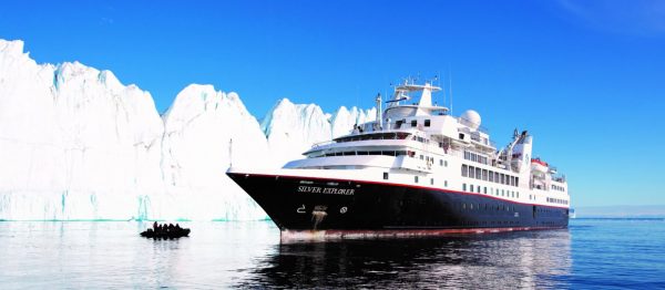
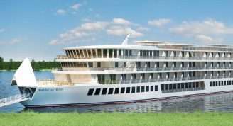
Vessel Type: Luxury Expedition Length: 108 metres Passenger Capacity: 144 Built / refurbished: 1989 / 2008 / 2018 Silversea’s purpose-built luxury Silver Explorer expedition cruise ship has been designed specifically for navigating waters in some of the world’s most remote destinations, including both of earth’s polar regions. A strengthened hull with a Lloyd’s Register ice-class notation (1A) for passenger vessels enables the Silver Explorer Expedition Cruise Ship to safely push through ice floes with ease. A fleet of 12 Zodiac boats allows Silversea Expedition guests to visit even the most off-the-beaten path locations and an expert Expedition Team provides insight and understanding to each unforgettable Silver Explorer luxury cruise adventure.

Itinerary


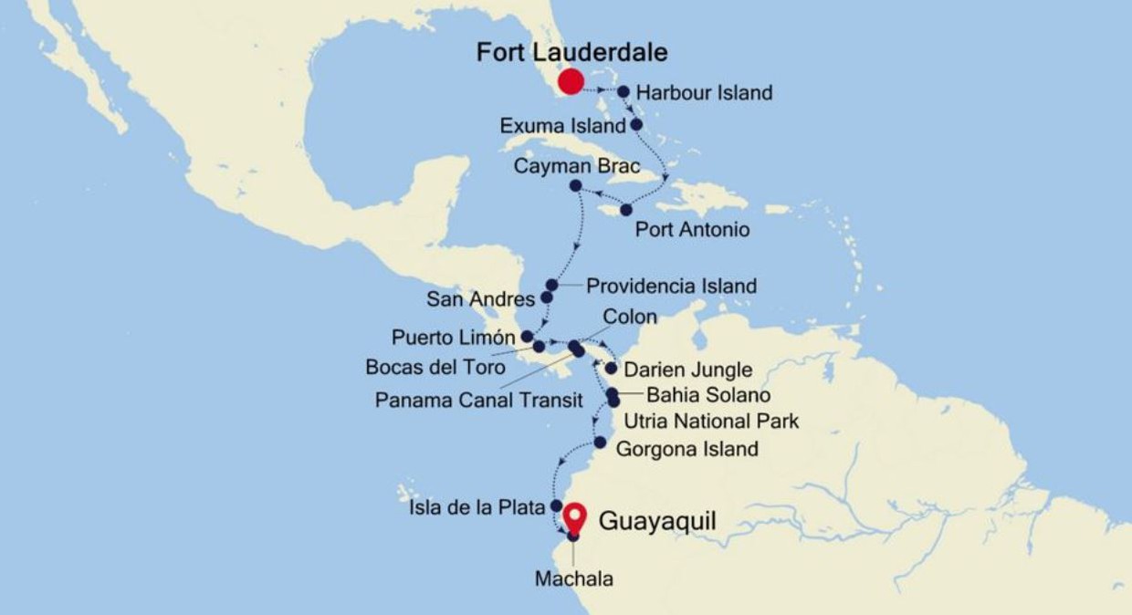
Day 1 - Day 1 Fort Lauderdale (Florida)
"Miles of sandy beaches, lively outdoor events, and a charming web of waterways help to make Fort Lauderdale a relaxed, vacation capital of Florida. The excitement is palpable, as cruise ships and gleaming yachts gather in the harbour ahead of adventures and luxury journeys across the waves. Soak up the relaxed atmosphere in the canal-laced 'Venice of America,' as you enjoy big label shopping on Las Olas Boulevard - or visit fancy restaurants and bustling art galleries. For a wilder experience, the swampy wetlands of the Everglades sprawl away nearby. Fort Lauderdale Beach is a lively stretch of sand, bordered by palm trees, and sprinkled with crowds enjoying the Sunshine State's generous weather. The charming promenade of red-brick tiles extends right along the beach's length and rumbles with passing rollerbladers and cyclists. Flick across the waves while paragliding, or relax with a coffee or a margarita in a beachfront bar, as volleyball games play out in front of you. For a quieter beach option, Olas Beach lies a little down the coast towards Port Everglades, and has extra space to spread out and tan on acres of smooth white sand. Spot the backs of alligators waiting patiently, and the toothy grins of crocodiles patrolling the murky waters of the Everglades – the USA's biggest tropical wetlands. A haven of extraordinary wildlife, birds wade through its swamps, and black bears and panthers roam its wilds. Take to a plane to appreciate the full scale of the national park or purr along exploring its waterways in a fan powered boat."
Day 2 - Day 2 Harbour Island
Harbour Island is a small slip of island, extending three miles from north to south and less than half a mile wide. The island at the northern tip of the much larger Eleuthera Island. Despite its small size it has about 1,700 residents and one incorporated town, Dunmore Town, named after the governor of the Bahamas John Murray, the 4th Earl of Dunmore (1785 to 1798 governorship). The island is known for its pink sand beaches – the pink comes from a microscopic organism (foraminifera) with a reddish-pink shell. Harbour Island charms every visitor, with its colorful Colonial houses and wild horses occasionally spotted running along the serene beaches.
Day 3 - Day 3 Exuma Island
Stretching over some 200 miles southeast of Nassau, the Exuma archipelago consists of 365 cays and islands. Next to Great Exuma and Little Exuma Moriah Harbour Cay National Park protects a wide array of habitats, including mangrove creeks, beautiful beaches, sand dunes, and sea grass beds. Birds found in the area include Ospreys, Gull-billed and Least Terns, plovers, oystercatchers, and the nocturnal nighthawks. But perhaps Exuma’s most famous non-human residents are Big Major Cay’s swimming pigs at Pig Beach.
Day 4 - Day 4 At Sea
a:0:{}
Day 5 - Day 5 Port Antonio
Port Antonio, on the Northeast coast of Jamaica, is the islands third largest port, mainly for bananas and coconuts. It is also an important tourist destination. In fact, it has been featured as a model of paradise in several famous Hollywood films such as Club Paradise and Cocktail. Port Antonio was a sleepy coastal town until the 1880s, when Lorenzo Dow Baker, an American businessman, started the banana trade in Jamaica and promoted Port Antonio as a vacation spot for wealthy Americans. "Portie", as it is nicknamed, became a boom town. Even the movie star Errol Flynn was enamoured and ended up buying property here after his yacht washed ashore in 1946. Today it is still a major destination with plenty to do and see, from stunning scenery, creative arts and crafts, and cultural and historical sites.
Day 6 - Day 6 Cayman Brac (Cayman Islands)
First spotted on his fourth and final trans-Atlantic crossing in 1503 and originally named Las Tortugas by Christopher Columbus because of the many turtles he spotted on the island, Cayman Brac rears up out of the water as if surrounded by a fort. Think craggy limestone shores (although archetypal sandy beaches and blue lapping seas are assured on the north of the island), which have kept this Cayman relatively free from mass tourism. Because of her geographical location (145km from Grand Cayman) and her challenging coastal approach, life has remained very laid back here, with local enterprises being stonemasonry and fishing, although some mass tourism is being developed thanks mostly due to its pristine underwater eco-system ensuring divers and snorkellers some very special sights. The Brac, or “Bluff” has however been a magnetic pull to climbers in recent years, with over 100 sport climbs mapped out on the easterly cliff face. Despite its rich historical past the island is assuredly modern. The middle child of the Cayman Islands, Cayman Brac is just 19kms long (although its little sister, Little Cayman is 16km, while Grand Cayman, although still small, is by far the largest at 35 km). Nevertheless, the plethora of hidden caves, nature trails and abundant wildlife both above and below the water make this little gem a paradise for nature lovers.
Day 7 - Day 7 At Sea
a:0:{}
Day 8 - Day 8 Providencia Island
Providencia, also known as Old Providencia or Providence, is the smaller of the two principal islands that form the Colombian Archipelago of San Andres, Providencia and Santa Catalina. The island sits 80km to the north-northeast of San Andres and is more mountainous than its bigger neighbour rising to 360 meters above sea level. Due to the island’s volcanic origin, with waterfalls and steep drops into the crystal blue sea, the vegetation is lush. Providencia is inhabited by fewer than 6000 people and is striving to retain its cultural history. Providencia’s towns are definitively Afro-Caribbean in style. The island has a wealth of pristine beaches and beautifully preserved reefs and has good snorkelling and diving sites. Its northeastern part has been declared a national park in order to protect its natural beauty. The sea surrounding Providencia is part of the UNESCO Seaflower Marine Protected Area and is on the tentative World Heritage list.
Day 9 - Day 9 San Andres Island
The San Andres and Providencia archipelago comprises Colombia's Caribbean islands, lying some 290 miles north of the South American coast. Palm-dotted San Andres is only eight miles long and two miles wide. It is noted for beautiful sand beaches, crystal-clear waters and good diving sites. At one time the island belonged to Britain and, according to local lore; it was a favorite hideout for the legendary pirate Henry Morgan. In 1822, San Andres came under the control of Colombia. In recent years the original population has greatly increased due to unrestricted immigration from the mainland. There are also Chinese and Middle Eastern communities. The official language is Spanish but English is widely spoken, especially in shops and hotels. The island is best seen via the scenic ring road that offers views of coves, beaches and palm groves. In the interior stands a Baptist church dating from 1847, and the attraction at the southern end is the Hoyo Soplador, a geyser-like hole where the sea shoots jets of water intermittently into the air during the right wind and sea conditions. On the island's northern tip lies the main town and commercial center, known by the same name as the island. San Andres Town is surrounded by beaches, with small hotels lining the waterfront. Being a duty-free zone, the town often gets crowded with Colombian shoppers who come from the mainland looking for foreign-made goods at duty-free prices. To reach the town from the tender landing requires an approximate 20-minute taxi ride. However, it is not uncommon for drivers to choose the longer way around the island for a higher fare. From the downtown waterfront, boats offer trips to Johnny Cay, a tiny island just a stone's throw across from town and known for its powdery white sand beach and rustic, laid-back atmosphere. San Andres Island’s main attraction is its location off the beaten track, as well as pretty scenery, sandy beaches and clear, warm waters. Tourism infrastructure is limited. Pier Information The ship is scheduled to anchor off El Cove. Guests will be taken ashore via the ship's tenders. The landing site is about a 20-minute drive from San Andres Town. There are plenty of taxi drivers offering their services. Please be sure to agree on the fare before setting out (the one-way fare should be around $30). Keep in mind that not all taxi drivers speak English. Shuttle buses are not available. Shopping Most shops in town carry duty-free imports. At New Point Plaza you will find shops selling local souvenir items and jewelry including emeralds. Some stores close between 12:30 p.m. and 3:00 p.m. The local currency is the peso. Many shops will accept U.S. dollars and major credit cards. Cuisine Outdoor cafés are available in town if you fancy a cold drink or a quick snack. Other Sites All of the island’s sights are covered on the San Andres Island Drive. Beaches Swimmers, snorkelers and sun seekers will find beach facilities right in town. One of the hotels also features water sport rentals. Johnny Cay can be reached via local boats departing from the waterfront. However, be aware that winds are fairly strong between November and January, which may cause delays for your return boat ride. There are no tourist facilities on Johnny Cay. Private cars/vans are not available in this port, except for taxis.
Day 10 - Day 10 Puerto Limón
Christopher Columbus became Costa Rica's first tourist when he landed on this stretch of coast in 1502 during his fourth and final voyage to the New World. Expecting to find vast mineral wealth, he named the region Costa Rica ("rich coast"). Imagine the Spaniards' surprise eventually to find there was none. Save for a brief skirmish some six decades ago, the country did prove itself rich in a long tradition of peace and democracy. No other country in Latin America can make that claim. Costa Rica is also abundantly rich in natural beauty, managing to pack beaches, volcanoes, rain forests, and diverse animal life into an area the size of Vermont and New Hampshire combined. It has successfully parlayed those qualities into its role as one the world's great ecotourism destinations. A day visit is short, but time enough for a quick sample.
Day 11 - Day 11 Bocas Del Toro
Translated as Mouths of the Bull, Bocas del Toro is both a province and an archipelago in the northwest Caribbean Sea in Panama. The archipelago contains 10 larger islands (including the main Isla Colon, where the town of Bocas del Toro is situated), 50 cays and 200 tiny islets. The region contains Isla Bastimentos National Marine Park, Panama’s first national marine park that covers over 32,000 acres and protects forests, mangroves, monkeys, sloths, caiman, crocodile and 28 species of amphibians and reptiles. The park also contains Playa Larga, an important nesting site for sea turtles. With all there is to see in this region, visitors should also pause to enjoy the pristine white beaches lined with palm trees that lie all along the surrounding clear waters of the Chiriqui Lagoon
Day 12 - Days 12 - 13 Colon
Colon welcomes you to one of humanity's most extraordinary engineering endeavours, the Panama Canal. This extraordinary waterway connects two of the world’s great oceans and, on opening, saved ships from an epic and treacherous 8,000 mile voyage around Cape Horn. While the Atlantic Entrance is Colon's main raison d’etre, there is much more to this city on the canal’s grand gateway than first meets the eye. Take an old world voyage on the regally romantic Panama Railway Canal, which preceded the canal and was constructed at extraordinary human cost to traverse Panama’s narrow land. The tracks have been rolling since the 19th century and cosying up inside the historic carriages, with their gleaming glass ceilings and polished woods, is an elegant journey back through time to the period when this was the quickest route from the east coast of the USA to California’s gold rush dreams. A side trip to the UNESCO World Heritage Site Portobelo is also a must. With its reef rock fortifications built by the Spanish in the 17th century, these jagged jaws of coral were carved to cut approaching pirates and conquistadors to shreds. It shares its World Heritage Site designation with nearby Fort San Lorenzo, which perches on an emerald-green cliff, casting its gaze over the harbour below. Back in Colon, after staring in awe at the grand, clanging Gatun Locks, and splurging on a case of duty-free rum and trinkets from the Colon Free Trade Zone - a trip to the beach will soothe city-worn souls. Playa La Angosta is a rabble of raucous beach-going fun, where the blue waters swirl with bright banana boats and fleeting canoes. Relax on the sand among sizzling yuca fritters, and families clamouring in the shade of cabanas. On the Caribbean side, Playa Chiquita is accessible only by boat, but rewards with warm gin-clear waters backed by thick rainforest.
Day 13 - Day 13 Panama Canal Transit
Enter the mighty Panama Canal, one of history’s most ambitious and spectacular stretches of waterway. Connecting the Atlantic and Pacific oceans, and slicing through the heart of a continent, the canal is a staggering engineering triumph, eliminating the need to traverse the treacherous waters of South America and Cape Horn. Sail one of the world’s great canals to appreciate the true scale of this achievement, as your ship manoeuvres between its vast, gushing locks and huge lakes. The French began construction in 1881, but the costly project was left abandoned and unfinished until the United States finally completed the work in 1914. Following the path of the Panama Railway of 1855, locks raise ships large and small 26 metres up above sea level to the canal’s elevated channel. New locks have recently been added, which allow the canal to accommodate ever bigger ships. Leaving the confinement of the locks, you will enter the canal’s channel, to sail through Panama’s core. Wide lakes are linked by painstakingly chiselled wedges of canal, which slice through the lush scenery. Look out for the Culebra Cut section, the most challenging stretch of the entire route to construct. The Bridge of the Americas is a vast arched landmark, which sweeps across the Pacific Entrance and was completed in 1962. It’s one of several huge bridges that you will sail below on the 51-mile journey, including the much newer Centennial Bridge, and the Atlantic Bridge, which spans the entrance close to Colon.
Day 14 - Day 14 Darien Jungle
The remote Darien Jungle has one of the most biodiverse ecosystems in the world. It is also one of the world’s top ten birding sites, with the colourful Crimson-collared Tanager, Chestnut-fronted Macaws, and Snow-bellied Hummingbirds found here. Mammals include tapirs and Black-headed Spider Monkeys. In this roadless stretch of forest, rivers provide the best access. Visitors to the Darien Jungle are rare with fewer than 1,000 tourists visiting each year. The Embera are one of several indigenous groups that live here in relative isolation offering ornate handcrafted baskets and carvings for sale in their traditional villages.
Day 15 - Days 15 - 16 Bahia Solano (Choco) & Utria National Park (Nuqui Harbour)
Bahía Solano is located in splendid isolation; connected to the outside world by a single, small local airport. Tucked inside a bay, the small Columbian town is lined by the Pacific Ocean on one side and thick, impenetrable jungle flush with waterfalls on the other. The majority of the 10,000 residents work in local industries, which are predominantly fishing, agriculture and eco-tourism. In addition to a quaint town with its local schools, shops, businesses, church, and library, there is a small fishing port here with a display of the locally caught fish, which are flown out daily to the main cities of Colombia. The village also supports a regional botanical reserve that is dedicated to the protection and conservation of local wildlife through education and recovery.Sitting on Colombia’s Pacific coast is the lush tract of Utría National Park. From coral reefs and mangroves in the marine realm, to tropical rainforest and rocky beaches where sea turtles come to lay their eggs, few places in the world encompass the diversity of Utría’s ecosystems. The forest here offers a choice of trails to explore. In addition to a wealth of wildlife, the park boasts several species of impressive timber trees, notably the area’s beloved Cohiba tree and the Oquendo tree, which are used in the creation of local art and handicrafts.
Day 16 - Day 17 Gorgona Island
Isla Gorgona is a beautiful tropical island and a national park. Packed with lush green rainforest, palm trees and beaches full of black volcanic rocks, this little island off the Colombian coast was used by Pizarro and his thirteen followers before they eventually went south to inspect and later conquer Peru. The island is named after its plentiful supply of snakes, which might have been one of the reasons to utilize the island until the 1980s as a prison. Today only limited amounts of visitors are allowed ashore to explore the prison ruins, hike in the rainforest or snorkel.
Day 17 - Day 18 Isla De La Plata
Isla de la Plata translates to ‘Island of Silver’, and the name was derived from the legend of swashbuckling pirate Sir Francis Drake’s buried silver treasure. The popular legend states that in the 16th century, hundreds of tons of silver and gold were never fully recovered and are still hidden on the island. The island was privately owned until 1979, when it was declared part of Ecuador’s Machalilla National Park. Best known for its fauna, which is amazingly similar to that of the Galapagos Islands, Isla de la Plata is a delightful place for birding, photography and long nature walks. Although just south of the equator, the influences of the colder Humboldt Current bring nutrient-rich water as far north as Isla de la Plata.
Day 18 - Day 19 Machala
Several National Sanctuaries and Ecological Reserves found near Machala boast sun-drenched beaches and mangrove forests. Pelicans, frigatebirds, and egrets nest nearby as Blue-footed Boobies dive for fish further out to sea. Whales and dolphins can occasionally be seen in the vicinity. Machala, with a population of approximately 250,000 inhabitants, is moreover known for traditional Latin American foods from shrimp ceviche to fried bananas. In fact, bananas feature heavily in the culture as the city is also known as the “Capital of the Banana.” During the third week of September the ‘World Fair of the Banana’ is held here and producers and buyers from Perú, Costa Rica, Colombia, Venezuela, México, Paraguay, Uruguay, Bolivia, Argentina, Guatemala, Panamá, República Dominicana, El Salvado, Honduras and Ecuador attend the event.
Day 19 - Day 20 Guayaquil
The second major jumping off point for the Galapagos Islands after Quito, this is a little city with a big heart. A sea port first and foremost, the city’s personality has been founded on that, and all the better it is for it too. Almost Caribbean in feeling, the clement climate coupled with the intermingling rhythms floating from the windows and abundance of fresh seafood make this a very tropical destination. Once not even considered by the travel books as a potential destination in its own right, the city has undergone something of a resurgence in the past few years. Proud Guayaquileños will not hestitate to point out the Malecón or the exciting new riverfront promenade, once a no-go area after dark, now happily (and hippily) lined with museums, restaurants, shops, and ongoing entertainment. The new airport and urban transportation network are also lauded to the happy tourists who find themselves here. As the largest and most populous city in Ecuador as well as being the commercial centre, it would only be natural that the city would have some kind of modern architecture, but it is the colourful favelas, or to use their real name guasmos, that cling to the side of the hillside like limpets that really catch your eye. A blend of old and new, the first inhabitants can be traced back to 1948 when the government cleared the area for affordable housing, these shanty towns are witness to the social and political particularities that Guayaquil has faced in the past.
Day 20 - Please Note:
Itineraries are subject to change.

Trip Dates

StartEndPrice FromRoom Type

Inclusions

    • Visit Bahamas & Jamaica
    • Explore Colombia, Costa Rica & Panama
    • Travel to Ecuador

Map