fbpx

Arctic Complete 2021 (Greg Mortimer)

Arctic Complete 2021 (Greg Mortimer)

From AUD $25,800

Description

Embark on a voyage to Svalbard, scanning for whales, the majestic polar bear and enigmatic walrus on pack ice. East Greenland dazzles with its iridescent icebergs and deep exploration in Scoresbysund – the world’s largest fjord system. Witness spectacularly colourful patterns in the sandstone rocks, visit remarkable Palaeolithic sites and have the chance to encounter musk oxen and arctic hare.

Trip Name
Arctic Complete 2021 (Greg Mortimer)
Days
23
Overview
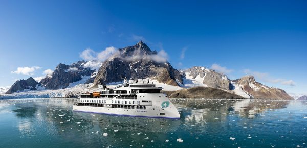
Vessel Type: Expedition Length: 104 metres Passenger Capacity: 132 Built: 2019 Capable of negotiating the strongest winds and waves, the Greg Mortimer is built to world-class polar standards – designed in close consultation with our expedition specialists, taking advantage of our more than 25 years of experience. The Greg Mortimer redefines expedition cruising for the future, with just 132 passengers on board in the polar regions. Not only is the ship bigger to contend with adverse weather conditions, its added creature comforts make for a more enjoyable journey out on the open ocean. The Greg Mortimer remains true to our ethos and focus on multiple landings, flexible itineraries and family atmosphere – just with an improved home base! As a modern and custom-designed ship, the Greg Mortimer is at the cutting edge of nautical technology. Robust, powerful and built with our guests in mind, this ship marks a significant investment in our fleet's capabilities. From the European Arctic to the depths of Antarctica, and other far-flung destinations in-between, the Greg Mortimer will make your journey a breeze! Greg Mortimer ULSTEIN X-BOW™ Our expeditions face some of the worst Mother Nature can throw at us. However, this won't be problem on the Greg Mortimer with the introduction of the patented X-BOW™, created by Norwegian ship designer ULSTEIN. As one of the leaders in marine engineering, ULSTEIN's X-BOW™ is an inverted bow concept that's been built on over 100 vessels in the shipping industry. Excitingly, we are the first expedition cruise operator to utilise this technology for the challenging open ocean waves!  Hydraulic viewing platforms  Although there is no doubt that you'll love the aesthetics of the Greg Mortimer, we are all here to admire the spectacular landscape and spot the elusive wildlife in their natural habitat. To ensure you get the best views possible, the new ship features unique viewing platforms, custom-built for the Greg Mortimer. Accessed from Deck 5, the two platforms fold out hydraulically for unobstructed views of passing marine life and seabirds – make sure your camera is locked and loaded! Zodiac launching platform Zodiacs are a vital part of getting up close and personal on your adventure – sneaking into areas that the Greg Mortimer can't reach. On this new ship, there are specially designed launching platforms that enables us to load Zodiacs easily and quickly, allowing you to spend more time exploring on the two to three daily landings. There are 15 Zodiacs that are boarded from either side of Deck 3 (sea level), perfect for when there is a group of fluffy cute penguin chicks that we need a photo of!  Activity Platform Regardless of your destination, we offer a number of additional activities to allow you to see more of the environment. From kayaking and diving to climbing and ski touring, it's these optional activities that often leave the biggest impression on your trip as a whole. Onboard the Greg Mortimer, there is a spacious prep and loading platform for these activities and more – designed in consultation with our expert activity guides. Environmentally friendly Climate change and carbon emissions continue to be major issues that everyone needs to be aware of and actively managing. This includes reduced emissions into the air and sea, lower energy consumption, high fuel efficiency, reduced light pollution for minimal wildlife disruption and lower on-board plastic use. It's vital to also mention the state-of-the-art virtual anchoring technology of the X-BOW™, which means the ship can float anchorless while launching Zodiacs, kayaks etc, without disturbing delicate sea floor areas.  Safety features This starts with the return-to-port equipment – not compulsory on a ship of this size – which duplicates the propulsion system. This enables the ship to maintain operating systems and comfort in the event of engine failure. Furthermore, the Greg Mortimer is Polar Code 6 compliant, holds BV class and is fully compliant with the latest SOLAS requirements. It's also built with a Rolls Royce stabiliser system.  If there's an incident or accident during your adventure, the ship has an on-board, fully-stocked medical centre – where our trained medical team can provide necessary treatment in a timely fashion. Safety continues to be an issue that our team takes very serious and the Greg Mortimer allows us to create an environment where you can concentrate on the brilliant landscape and wildlife, without worrying about your wellbeing. Ship Life Greg Mortimer is designed to serve your every need. It's your bedroom, bathroom, lounge, dining room and even your observatory. Make yourself at home, the Greg Mortimer is yours to enjoy! Observation Points Let's face it – you don't want windowless rooms when travelling around some of the most beautiful locations around the world. This is why the Greg Mortimer is designed with plenty of dedicated observation spaces – ideal for keen bird spotters, wildlife watchers and those wanting to watch the scenery go past. From the indoor 180-degree lounge and outdoor 360-degree open deck, both on deck 8, to the 270-degree open sundeck on level 7, there are plenty of observation points to share around the ship! If these are full, then you can take up a spot on one of the two hydraulic viewing platforms on deck 5. Aurora Expeditions also has an open bridge policy, which means at any point you can come up to the bridge and check out what the captain and officers are up to. From watching navigational practices to observing mapping techniques, you can get a firsthand look at the inner workings of the Greg Mortimer.  Shore excursions Although the ship is fun, the real enjoyment comes from the many shore excursions that are available. Depending on the weather and itinerary, it's possible to take two to three landings daily, taking a look at everything from rock formations and ancient ruins to cute groups of penguins. We know time is of the essence in these wild locations, so the Greg Mortimer has been designed with 15 Zodiacs, which means you can maximise your time on shore. From four dedicated sea level launching platforms, transfers are quicker, safer and enable you to get closer to the action for a longer period of time. Just remember to charge your camera before you step onto the Zodiac! Activity options From kayaking and skiing to diving and climbing, these are one-in-a-lifetime opportunities that you need to take advantage of.  Aboard the Greg Mortimer there is a specially designed launching platform for all activities, a concept overseen by our activity experts. This area also includes individual lockers in the expansive mudroom and rapid drying areas for wetsuits so you can quickly get warm after exploring in the elements!   Dining From the moment you step onto the Greg Mortimer, we aim to give you the best hospitality service possible. Starting with the official Captain's welcome, as our guests, you're welcome to 24 hours complimentary coffee, tea and snack facilities in addition to the range of different menu options and courses for each meal. Meals are served in large dining room/restaurant with family style dining, perfect to swap stories with your new expedition family. Enjoy the range of house wine, beers and soft drinks included with dinner after a long day in the wild, preparing yourself for another exciting day to follow. On the last day of your trip, the team on the Greg Mortimer put on a special farewell four-course dinner and cocktails – a perfect way to reflect on your time on the ship and consolidate lifelong friendships with the people you've met on-board. On-board entertainment When you’re relaxing during a sea day or you have a little downtime on the ship between excursions, what is there to do onboard the Greg Mortimer? Plenty! On all our expeditions, there are experts who lead presentations in the spacious lecture room so you can understand the region a little better. These often include topics as broad as history and culture to biology and climate change, these presentations aim to educate and entertain. If you're keen to just watch the surroundings and keep your eyes peeled for wildlife, you have access to two bars/lounges where the stunning floor to ceiling windows offer a special perspective on the landscape. The Greg Mortimer is also decked out with other facilities for your enjoyment. There is a library on Deck 5 with books and maps and a Wellness Centre complete with gym equipment, sauna and spa. Feeling a little sore after walking around all day? Treat yourself to a massage at the Wellness Centre and feels the aches disappear! Keen photographers and artists will revel in the multimedia room on Deck 5.

Itinerary


Day 1 - Day 1 Reykjavik, embark Greg Mortimer
After making your own way to Reykjavik pier, embark the Greg Mortimer in the late afternoon from 4.00 pm. You’ll have time to settle into your cabin before our important briefings.
Day 2 - Day 2 Denmark Strait
In the Denmark Strait, we cruise towards Greenland. We will be on the lookout for whale blows and the many seabirds that trail our ship in the constant winds. In our lecture theatre, enjoy informative and entertaining presentations from our experts on topics such as seabirds, wildlife, and ice, or catch up on some rest after busy days of travel.
Day 3 - Days 3-9 East Greenland
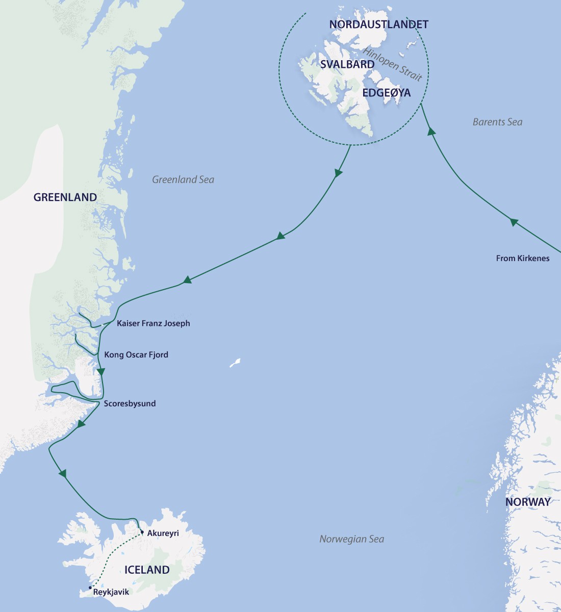
As we approach East Greenland, we may encounter more pack ice where we may see seals and a variety of seabirds, including northern fulmar and migratory Brunnichs guillemots. This stretch of coastline is ripe for exploration, with its many secrets locked in place by drift ice for up to eight months each year.Our experienced expedition team, who have made countless journeys to this area, will use their expertise to design our voyage from day to day. This allows us to make best use of the prevailing weather, ice conditions and wildlife opportunities. We will generally make up to two landings or Zodiac excursions per day; cruising along spectacular ice cliffs, following whales that are feeding near the surface.Over the coming days, be prepared to experience ice, lots of it. East Greenland contains some of the Arctic's most impressive scenery. Deep fjords and narrow channels, flanked by sharp ice-clad peaks up to 2,000 m / 6,562 ft high. Glaciers create gigantic icebergs that drift throughout the fjord system creating breath-taking scenes. The landscape is filled with multi-coloured tundra home to musk oxen and Arctic hare. Throughout the area are ancient Thule archaeological sites, historical trappers' huts, and modern Inuit hunters' cabins. A highlight is a visit to the Inuit village of Ittoqqortoormiit, the most isolated and northernmost permanent settlement in the region, with approximately 450 inhabitants. The community boasts an excellent museum, gift shop, an abundance of Greenlandic sled dogs, and the opportunity to meet Inuit people.Explore Scoresbysund, the largest fjord system in the world – a spectacular place that simply needs to be seen to be believed. North of Scoresbysund are, Kong Oscar and Kaizer Franz Josef fjords, two of the most significant fjord systems in all of Greenland, each one encompassing several smaller fjords and sounds. Thanks to the fertile volcanic soil mountains that protects areas from the strong winds, the area is rich in wildlife. You may spot everything from muskox and arctic foxes to mountain hares and even reindeer near the fjord. Look skyward and you could catch a glimpse of birds including glaucous gull, black-legged kittiwake, northern fulmar, common raven and common eider.We will attempt to enter Kaiser Franz Josef Fjord, a remote and rarely visited fjord system with countless opportunities for exploration within the Northeast Greenland National Park. Cruising through Kong Oskar Fjord we will marvel at the geological beauty of the mountains. We will then head south along the coast of Liverpool Land, with our passage dependent on ice conditions. We aim to reach Scoresbysund, the world’s biggest fjord and a favourite hunting ground of the local Inuit. Massive glaciers dump into this fjord, the birthplace of the famous big Greenland icebergs.We plan to visit the remote Inuit community of Ittoqqortoormiit (Scoresby Town) and to hike across the tundra in search of ancient graveyards and summer villages occupied 3,000 years ago by Eskimos. This area provides excellent opportunities for sea kayaking in its maze of calm, interconnecting waterways. We may see musk oxen, arctic hare and seals, and maybe if we are extremely lucky even a polar bear or narwhal, although due to the local hunting traditions, these sightings are often very rare.Places we may land along the east coast include:Cape Humboldt is a beautiful bay on Ymer Island. There is a good chance to take a tundra walk and see musk oxen graze. We will also keep a lookout for Arctic fox and ptarmigan. A lone trapper's hut looks over the bay and magnificent icebergs.Sefstrom Glacier adorns the narrow-peaked waterway in Alpefjord. Enjoy Zodiac cruising and kayaking in this pretty area, where colourful Arctic flora adorns the tundra ground.Ittoqqortoormiit is Scoresbysund’s colourful Inuit community of approximately 500 people. Here you can explore the village, the fascinating museum or sit in the beautiful Lutheran Church. The locals are friendly and from underneath their Arctic fox-fur jackets, the shy young children are keen to say hello and practice their English.Sydkap in Scoresbysund offers good walking and delightful views across the sound. Kayakers will have good opportunities to explore the lonely beaches. We may explore the ancient gravesites on the island, or the lakes with green tunnels and giant icebergs offer hours of enjoyment for kayak and Zodiac rides.RømerfjordRømer Fjord with its narrow channels and towering peaks is simply stunning, and lies roughly 167 km / 104 mi south of Scoresbysund. There are great hiking options in the fjord where flowering tundra plants, scattered bones of whales and muskox from centuries of hunting by the Inuit, and fumaroles can be found. These are areas where heated groundwater boil to the surface creating bubbling pools and mineral formations as the water reacts with the atmosphere.Rode ØRode Ø Island is a glorious place for Zodiac cruising, hiking and kayaking, with its rich red Devonian sandstone geology. Discover the impressive mafic dyke that runs through the east side of Rode Ø. Glaucous gulls find perfect perches and nesting sites along the top of the basalt extrusions. Kayak along the maze of icebergs - pillars and arches, caves and peaks that look as though an artist had sculpted them.Hare FjordThe scenery here is breathtaking. Walk across the tundra alongside a ravine or Zodiac cruise where you might find musk ox, along with flitting shore birds, seals and a variety of colours in the lush Arctic tundra. Kayakers can enjoy sublime paddling in one of the most remote fjords in the world. Nearby is the spectacular and impressive Ø Fjord, a perfect place for small ship cruising.Nordvest FjordIf mountains rising 1,200 m / 3,937 ft straight out of the water wasn’t enough, how about the fjord itself, descending to 1,500 metres? There are also countless icebergs pouring out of the Daugård-Gensen Glacier. A great place for kayaking and Zodiac cruising with plenty of gorgeous bergs while the glacier itself, seemingly small from a distance, proved to be a formidable river of ice snaking down the valley.EskimobugtNo one can state the exact age of the neo-Eskimo site at Eskimobugt, but it may only be a few hundred years old. Subterranean winter houses designed with a tunnel that faces the sea where occupants would crawl through to the stand-up living chamber; at the opposite end is the sleeping platform. The walls were erected with carefully laid stones while the roof structure would be built from whatever material was available - driftwood, walrus bone, and available skin covering. Fire hearths were created by laying rocks in a circle with a bed of white quartzite stones. Learn from our historian about the incredible resourcefulness of the Inuit people whose men travelled formidable distances by kayak to hunt, and whose women crafted sophisticated garments from animal skins and fur – a people for whom survival in such extremes was paramount. Hiking here offers panoramic views, sightings musk ox and, occasionally Arctic hare.SkipperdalenSee some of the most striking sedimentary sandstone, shale and siltstone formations imaginable. The alternating colours and patterns in the layers of rocks defied belief, and the layers of sediment here are estimated to have taken about 4,000 years to be laid down. You can also find the remains of a simple but highly effective wooden fox trap in use by Norwegian trappers in both Greenland and Svalbard from the early 1900s to 1960s. Skippendalen is also a marvellous place to hike and paddle in kayaks.Other possible landing points in the area include:• Rypefjord• Nordenskjöld glacier & Blomsterbugten• Alpenfjorden• FjordFonfjord• Bjorn Oya• Milne Land• Hekla Havn• Denmark Island
Day 4 - Days 10-11 Greenland Sea
We head out to sea bound for Spitsbergen. As we cruise northeast across the Greenland Sea – the main outlet of the Arctic Ocean – we may encounter pack ice, and if we’re lucky we will see polar bears hunting on the ice. The strong icy sea currents have isolated East Greenland from the rest of the world for millennia. These currents carry nutrients from the Polar Basin, attracting large numbers of fish, seals and whales. Climatic conditions and the concentration of ice in the vicinity often create thick morning fog that vanishes with the onset of the midday sun. Our experts will inform and entertain us with fascinating talks on plants, animals and early explorers like Nansen, Andree and Scoresby.
Day 5 - Days 12-22 Svalbard Archipelago
Svalbard offers unspoiled, raw Arctic wilderness at its best. With majestic mountains, iridescent sea ice, countless glaciers and superb wildlife-viewing opportunities. Our experienced expedition team, who have made countless journeys to this area, will use their expertise to design our voyage from day to day, choosing the best options based on the prevailing weather, ice conditions and wildlife opportunities.We generally make landings or Zodiac excursions twice a day. You’ll want to rug up before joining Zodiac cruises to witness walrus colonies hauled-outs on sea ice or on beaches, under towering cliffs of nesting sea birds or glide past glistening icebergs in your kayak.Without a doubt, our goal is to encounter the majestic polar bear on the pack ice, and the expedition team are just as keen as you to find them. Ship cruise along spectacular fjords, hike upon colourful tundra, perhaps tasting wild blueberries along the way.Some of the places where we may enjoy landings for deeper exploration or view spectacular wildlife and scenery follows:Kongsfjorden (Kings Bay)Kongsfjorden and the surrounding country are known to be one of the most beautiful fjord areas in Svalbard. The fjord is headed by two giant glaciers, Kronebreen and Kongsvegen. Hike on the lush tundra amongst the summer flowers and observe the remarkable bird cliffs near the 14th July Glacier, where even a few puffins nest between the cracks in the cliffs.In this area we find the former mining settlement of Ny-Ålesund. Situated at 78º 55' N, Ny-Ålesund is one of the world’s northern-most year-round communities. The settlement of Ny-Ålesund is strongly linked to coal mining operations, scientific expeditions and recently also to various international research efforts. It is located more than 100 km north of Longyearbyen and is one of the northernmost settlements in the world. In and around Ny-Ålesund, the largest concentration of protected buildings, cultural monuments and various remains in Svalbard can be found, making the area an important cultural heritage site. Ny-Ålesund is the largest Norwegian settlement in Svalbard that was spared from being burned down during World War II. The settlement is well preserved and serves as a valuable historical source.Ny-Ålesund has also been the starting point of several historical attempts to reach the North Pole. Names like Amundsen, Ellsworth and Nobile are strongly linked to Ny-Ålesund. Since 1964, Ny-Ålesund has also been a centre for international Arctic research and environmental monitoring. A number of countries run their own national research stations here, and research activity is high in the summer.The islands and islets in the inner part of Kongsfjorden are teeming with seabirds. At the head of the fjord, mighty glaciers calve into the sea. All of this is framed by majestic mountain formations. Further north-west lies Krossfjorden, with its cultural remains from the whaling period, Russian and Norwegian overwinterings and World War II. Large bird cliffs are also found here.Nordvesthjørnet and RaudfjordenIt was here, in the far north-west, that Willem Barentsz and his crew discovered new land on 17 June, 1596. They described the land as being “rugged for the most part, and steep, mostly mountains and jagged peaks, from which we gave it the name of Spitsbergen”. In the centuries that followed, the large number of bowhead whales found here attracted whalers from the Netherlands and various other countries. Nordvesthjørnet offers the largest concentration of graves, blubber ovens and other cultural treasures on Spitsbergen, all dating back to this first era of the exploitation of Svalbard’s natural resources.MagdalenefjordenMagdalenefjorden is located inside the Northwest Spitsbergen National Park. According to historical sources, Magdalenefjorden was first used by the English in the early days of the whaling era. They built a land station on the headland and named the area Trinity Harbour.The spectacular alpine scenery is lined with jagged mountain peaks, to which Spitsbergen (‘pointed mountains’, in Norwegian) owes its name. At 1,115 metres / 3,658 feet, Hornemanntoppen is the highest mountain in the area, and is located east of Magdalenefjorden. The topography of the area is mostly rocky, shorelines are covered with stones and hiking here can be challenging. Little auks breed here in large numbers, and a few reindeer can still be seen roaming around on mossy slopes. Very occasionally, polar bears and walrus are seen here.SmeerenbergThe name “Smeerenburg” means “Blubber Town”. Its whaling station served as the main base for Dutch whaling in the first half of the 17th century, when whaling was still occuring along the coastline and in the fjords of Svalbard. Smeerenburg is situated on the island of Amsterdamøya, surrounded by fjords, tall glacier fronts and steep, rugged mountains. The most obvious sign of its whaling station history are the large cement-like remains of blubber from ovens where the blubber was boiled.VirgohamnaVirgohamna is most famous for being the starting place of many expeditions that attempted to reach the North Pole. On the beach, are the remains of blubber ovens and a Dutch whaling station. Written permission from the Governor of Svalbard is required in order to land here.Ytre NorskøyaYtre Norskøya is situated in the middle of what used to be hub of the Dutch whaling area, when it all revolved around land-based stations for boiling the whale blubber. The station is situated by the sound Norskøysundet, between the islands of Ytre Norskøya and Indre Norskøya. A sheltered bay offers protection against the weather and a broad beach facilitates landings. Today, the remains of nine blubber ovens lie in a line along the beach. Containing around 165 graves, the island is one of the largest burial grounds in Svalbard.Woodfjorden, Liefdefjorden and BockfjordenLocated along the north coast, Woodfjorden, Liefdefjorden and Bockfjorden are rarely-visited places. Near Reinsdyrflya lies a great fjord system that stretches towards several mountain ridges including; alpine summits of ancient granite, majestic red mountains of Devonian sandstone, cone-shaped remnants of three volcanoes and even hot springs. Large glacier fronts calve in the sea, while polar bears are busy hunting for ringed seals and sweeping the islets for birds’ eggs. Hike in the mountains on the tundra where brightly-coloured wildflowers and lichen grow, and where reindeer graze. We may visit trapper huts of yesteryear where Russian Pomors would hunt and survive the cold harsh winters, all while remaining alert for wandering polar bears and their cubs.Nordaust-Svalbard Nature ReserveNordaust-Svalbard Nature Reserve is the most high-Arctic part of Svalbard. The fjords are covered in ice, and drift ice floats around the islands for most of the year. Glaciers cover large areas of the terrain. This is the kingdom of the polar bear and walrus. It has been protected as a nature reserve since 1973.Nordaustlandet The second largest island in Svalbard, with an area of 14,443 km². It is part of Nordaust-Svalbard Nature Reserve. The two large ice sheets of Austfonna and Vestfonna cover large areas of the island. The landscape is open and majestic with different types of landscapes, from the prominent fjords in the west and north to the massive glacier front facing east and south. From a distance, Nordaustlandet appears cold, unfriendly and unproductive. However, many places are unexpectedly lush, especially close to the bird cliffs.Moffen IslandMoffen Island is situated directly north of 80°N. After the near-exctinction of walrus in Svalbard in the middle of the 20th century, Moffen Island played an important conservation role and helped to re-establish the population here, a process which continues today. Large numbers of walrus can be found hauled out at the southern tip of the island and in summer, vessels must remain at least 500 m / 1,640 ft away.SjuøyaneIn ocean north of Nordaustlandet lies the little archipelago of Sjuøyane (the seven islands), with its characteristically hat-shaped mountains. The hard granite mountains have a green covering of moss due to thousands of breeding seabirds. Walrus dive for clams in the waters between the islands and in the bays. Most of the islands have been named after the English North Pole expeditions led by Phipps (1773) and Parry (1827).Polar bears can be spotted anywhere on Sjuøyane. Polar bear distribution is strongly related to the distribution of sea ice. Drift ice around the islands offers increased chances of polar bears sightings. Reindeer and Arctic fox are also commonly encountered on Sjuøyane.When the ice breaks up around Sjuøyane and the first seabirds return from April–May, the islands wake from a long winter slumber. Huge bird cliffs can be found here. Little auks migrate in the largest numbers, followed closely by Atlantic puffins and guillemots. Near-threatened species of ivory gulls can be found on Phippsøya along with several walrus haul-out sites, where hundreds of the marine giants can be found in the shallow bay.Hinlopen StraitAlong the northeast coast of Spitsbergen we enter a different world – a polar desert. Ice conditions permitting, we pass through the narrow Hinlopen Strait, flanked by creamy coloured slabs of rock that are rich in fossils, where Polar bears are often sighted on the islands or around the bird cliffs.Alkefjellet to the south of Lomfjorden is the largest bird cliff in the area with several hundred thousand black-legged kittiwakes and as many Brünnick’s guillemots. There are also several colonies of northern fulmar in the area, and little auks nest scattered in Hinlopen Strait. Brünnich’s guillemots nest in many colonies, including on the island of Wahlbergøya. Black-legged kittiwakes and black guillemots also breed in several of the colonies, most of them west of Hinlopen Strait, but also around Wahlenbergfjorden. One of the colonies is on Selanderneset. Common eiders also nest in many places, but the locations have been very poorly mapped. However, there is known to be a large colony on the island of Lemströmøya, north of Wahlbergøya.Several of the most famous and most visited haul-out sites for walrus can be found in Hinlopen Strait. Worth mentioning are Augustabukta/Torellneset and Vibebukta. White whales, ringed seals and bearded seals also occur in the area.The abundance of reindeer in the area varies greatly. The density is highest where the vegetation is most pronounced, such as the inner parts of Lomfjorden, at the bottom of Wahlenbergfjorden, in Palanderdalen and on Scaniahalvøya. A smaller number of reindeer are also scattered around the islands in Hinlopen Strait, and the Arctic fox can be seen on both sides of the strait. There is no doubt that the easiest place to observe foxes is around the bird cliffs. This is often also where dens can be found so we avoid entering these areas.Barentsøya and EdgeøyaEast of Spitsbergen are two large islands called Barentsøya and Edgeøya. The area has a rich array of wildlife, especially polar bears, reindeer, walrus, seabirds and geese. West of Edgeøya, cultural remains from the time of European whaling can be found, mainly Russian and Norwegian.AlkhornetAlkhornet, at the northern entrance of Isfjorden, is a striking landmark. The landscape around this large bird cliff is lush and beautiful. Alkhornet and Trygghamna offer an interesting combination of cultural history and nature. The name Trygghamna refers to the West European whaling activity was carried out around Svalbard in the 17th century when whales would swim into the fjords and hunted.At Alkhornet, reindeer are often sighted, along with Arctic fox, geese nesting on rocks and higher up on the cliffs, where Brünnich’s guillemots breed in enormous quantities. The cliffs at Alkhornet are also home to large colonies of breeding kittiwake and Arctic skuas. Glaucous gulls often patrol the air around the cliffs, hunting vulnerable prey.HornsundHornsund is the southernmost fjord in Svalbard located in Sør-Spitsbergen National Park, where majestic peaks and dramatic fjords are the defining features. The highest summits are often shrouded in mist, but if you’re lucky you might get a glimpse of Hornsundtind, peaking at 1,431 m / 4,695 ft. Traces of human activity spanning 400 years can be found almost anywhere where there are possible landing sites.Little auks are found here in huge numbers, drawn to the large scree slopes – their typical nesting habitat. With abundant plankton and crustaceans, Hornsund and the areas off the west coast are a giant food reservoir for the little auk. The West Spitsbergen Current – a branch of the Gulf Stream – brings temperate waters north along the western Spitsbergen coast and provides favourable conditions for biological production in the area.Northern fulmar can be seen in several colonies in Hornsund. Brünnich’s guillemot and kittiwake nest at the same locations. Dunøyane and Isøyane, islands that gained protection status as bird sanctuaries back in 1973, are important nesting areas for barnacle geese, pink-footed geese and brent geese. Pink-footed geese nest in large numbers on Dunøyane and on scree slopes and hillsides close to the sea, including in Hyttevika north of Hornsund and Gnålodden.A huge colony of little auks is situated at Ariekammen (100,000 to one million) – possibly the largest in Svalbard. If you’ve ever been close to such a large colony of swarming little auks, you’ll never forget it.BellsundBellsund cuts into Spitsbergen south of Isfjorden and splits into two branches at Van Mijenfjorden and Van Keulenfjorden fjords. The area features large bird cliffs, where fertilization by seabird droppings accounts for the surprisingly lush vegetation in some areas.Other places we may visit around the Svalbard Archipelago include:• Sundnest• Gnalodden• Freemanshundet• Hamiltonbukta• Lilliehookbreen• Gnalodden• Kapp Lee• Varsolbukta
Day 6 - Day 23 Disembark Longyearbyen
During the early morning we cruise back into Longyearbyen. Farewell your expedition team and enjoy a town tour, where you will visit Svalbard Museum and Galleri Svalbard, and take in the main sights of Longyearbyen including Office of the Governor, Svalbard Church, Nybyen (new town), a few of the town’s mines such as Santa Claus Mine, and a quick photo stop at the famous beware of polar bear street sign. Afterwards, transfer to the airport for your onward journeys.NOTE: At the conclusion of the voyage, we do not recommend booking flights departing prior to 12.00 pm on the day of disembarkation in case there are delays.
Day 7 - Please Note:
In true expedition style we encourage exploration and adventure, offering flexibility in challenging environments in a way that puts you among the action to see and do as much as possible. This itinerary is only a guide and subject to change due to ice and weather conditions.
Day 8 - Day 25 – Reykjavik, Iceland
Disembark the Greg Mortimer in the northern town of Akureyri, then enjoy a scenic transfer to downtown Reykjavik.
Day 9 - Please Note:
In true expedition style we encourage exploration and adventure, offering flexibility in challenging environments in a way that puts you among the action to see and do as much as possible. This itinerary is only a guide and subject to change due to ice and weather conditions.

Trip Dates

StartEndPrice FromRoom Type
21-08-202112-09-2021AUD $25,800Balcony Stateroom - C
21-08-202112-09-2021AUD $26,800Balcony Stateroom - A
21-08-202112-09-2021AUD $39,400Captain's Suite

Inclusions

    • Sail past Spitsbergen’s narrow sheltered waterways and fjords
    • Venture close to 80° north looking for polar bears on the pack ice
    • Listen to the orchestra of Greenland’s famous ice singing as it pops, hisses, cracks and calves
    • Delight in a variety of diverse terrain: ice caps, polar desert, alpine ranges, and hike through colourful tundra

Map